Tools for querying, downloading, and networking both the National Hydrography Dataset (NHD) and NHDPlus datasets.
Installation
CRAN policy is that no package can write to a persistent location by default. As a result, nhdR writes all data to a temporary location unless a temporary = FALSE argument is passed to the nhd_plus_get/nhd_get functions. Alternatively, nhdR will automatically write data to a persistent location if the nhdR_path environment variable is set. To do this, add the following line to your .Rprofile:
Sys.setenv(nhdR_path = file.path(rappdirs::user_data_dir(appname = "nhdR",
      appauthor = "nhdR")))
Your .Rprofile file can be edited using the usethis::edit_r_profile() function.
Stable version from CRAN
install.packages("nhdR")or development version from GitHub
# install.packages("devtools")
devtools::install_github("jsta/nhdR")
This package also requires an installation of 7-zip that can be called via the command line using 7z or 7za.exe (check if your machine is good to go with nhdR:::has_7z()).
Usage
NHD Plus
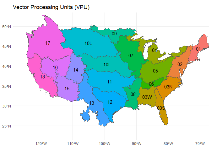
NHD-Plus exports are organized by vector processing unit (vpu). See below for a low resolution vpu map (also nhdR::vpu_shp). A hi-res version can be found here.
# get a vpu export
nhd_plus_get(vpu = 4, "NHDSnapshot")
nhd_plus_get(vpu = 4, "NHDPlusAttributes")
nhd_plus_get(vpu = 4, "NHDPlusCatchment")
# list layers
nhd_plus_list(vpu = 4, "NHDSnapshot")
#>  [1] "NHDArea.dbf"                "NHDAreaEventFC.dbf"
#>  [3] "NHDAreaEventFC.shp"         "NHDArea.shp"
#>  [5] "NHDFCode.dbf"               "NHDFlowline.dbf"
#>  [7] "NHDFlowline.shp"            "NHDFlowline.shp.xml"
#>  [9] "NHDLine.dbf"                "NHDLineEventFC.dbf"
#> [11] "NHDLineEventFC.shp"         "NHDLine.shp"
#> [13] "NHDPoint.dbf"               "NHDPointEventFC.dbf"
#> [15] "NHDPointEventFC.shp"        "NHDPoint.shp"
#> [17] "NHDReachCode_Comid.dbf"     "NHDReachCrossReference.dbf"
#> [19] "NHDWaterbody.dbf"           "NHDWaterbody.shp"
nhd_plus_list(vpu = 4, "NHDPlusAttributes")
#>  [1] "CumulativeArea.dbf"              "DivFracMP.dbf"
#>  [3] "elevslope.dbf"                   "HeadwaterNodeArea.dbf"
#>  [5] "MegaDiv.dbf"                     "PlusARPointEvent.dbf"
#>  [7] "PlusFlowAR.dbf"                  "PlusFlow.dbf"
#>  [9] "PlusFlowlineLakeMorphology.dbf"  "PlusFlowlineVAA.dbf"
#> [11] "PlusWaterbodyLakeMorphology.dbf"
nhd_plus_list(vpu = 4, "NHDPlusCatchment")
#> [1] "Catchment.dbf"         "Catchment.shp"         "featureidgridcode.dbf"
# get layer info
nhd_plus_info(vpu = 4, "NHDSnapshot", "NHDWaterbody")
#> [1] "Driver: ESRI Shapefile; number of rows: 31830 "
#> [2] "Feature type: wkbPolygon with 3 dimensions"
#> [3] "Extent: (-93.24332 40.43575) - (-73.61814 48.11344)"
#> [4] "CRS: +proj=longlat +datum=NAD83 +no_defs "
#> [5] "LDID: 87 "
#> [6] "Number of fields: 12 "
#> [7] " name type length typeName"
#> [8] "1 COMID 0 9 Integer"
#> [9] "2 FDATE 9 10 Date"
#> [10] "3 RESOLUTION 4 7 String"
#> [11] "4 GNIS_ID 4 10 String"
#> [12] "5 GNIS_NAME 4 65 String"
#> [13] "6 AREASQKM 2 19 Real"
#> [14] "7 ELEVATION 2 19 Real"
#> [15] "8 REACHCODE 4 14 String"
#> [16] "9 FTYPE 4 24 String"
#> [17] "10 FCODE 0 9 Integer"
#> [18] "11 SHAPE_LENG 2 19 Real"
#> [19] "12 SHAPE_AREA 2 19 Real"
# load layer
dt <- nhd_plus_load(vpu = 4, "NHDSnapshot", "NHDWaterbody")
#> Reading layer `NHDWaterbody' from data source `/home/jose/.local/share/nhdR/NHDPlus/GL_04_NHDSnapshot/NHDWaterbody.shp' using driver `ESRI Shapefile'
#> Simple feature collection with 31830 features and 12 fields
#> geometry type:  POLYGON
#> dimension:      XYZ
#> bbox:           xmin: -93.24332 ymin: 40.43575 xmax: -73.61814 ymax: 48.11344
#> epsg (SRID):    4269
#> proj4string:    +proj=longlat +datum=NAD83 +no_defs
NHD
NHD exports are organized by US state.
nhd_list(state = "DC")
#>  [1] "ExternalCrosswalk"           "NHDFCode"
#>  [3] "NHDFeatureToMetadata"        "NHDFlow"
#>  [5] "NHDFlowlineVAA"              "NHDMetadata"
#>  [7] "NHDProcessingParameters"     "NHDReachCodeMaintenance"
#>  [9] "NHDReachCrossReference"      "NHDSourceCitation"
#> [11] "NHDStatus"                   "NHDVerticalRelationship"
#> [13] "NHDPoint"                    "NHDFlowline"
#> [15] "NHDLine"                     "NHDArea"
#> [17] "NHDWaterbody"                "NHDAreaEventFC"
#> [19] "NHDLineEventFC"              "NHDPointEventFC"
#> [21] "WBDLine"                     "NonContributingDrainageArea"
#> [23] "NWISBoundary"                "NWISDrainageArea"
#> [25] "WBDHU14"                     "WBDHU8"
#> [27] "WBDHU2"                      "WBDHU4"
#> [29] "WBDHU6"                      "WBDHU10"
#> [31] "WBDHU12"                     "WBDHU16"
#> [33] "HYDRO_NET_Junctions"
#> attr(,"driver")
#> [1] "OpenFileGDB"
#> attr(,"nlayers")
#> [1] 33
nhd_info(state = "DC", dsn = "NHDWaterbody")
#> Source: "/home/jose/.local/share/nhdR/NHDH_DC.gdb", layer: "NHDWaterbody"
#> Driver: OpenFileGDB; number of rows: 8025
#> Feature type: wkbPolygon with 3 dimensions
#> Extent: (-78.07095 38.52142) - (-76.82219 39.64683)
#> CRS: +proj=longlat +datum=NAD83 +no_defs
#> Number of fields: 12
#>                    name type length typeName
#> 1  Permanent_Identifier    4     40   String
#> 2                 FDate   11      0 DateTime
#> 3            Resolution    0      0  Integer
#> 4               GNIS_ID    4     10   String
#> 5             GNIS_Name    4     65   String
#> 6              AreaSqKm    2      0     Real
#> 7             Elevation    2      0     Real
#> 8             ReachCode    4     14   String
#> 9                 FType    0      0  Integer
#> 10                FCode    0      0  Integer
#> 11         Shape_Length    2      0     Real
#> 12           Shape_Area    2      0     Real
head(nhd_load(state = "DC", dsn = "NHDWaterbody"))
#> Reading layer `NHDWaterbody' from data source `/home/jose/.local/share/nhdR/NHDH_DC.gdb' using driver `OpenFileGDB'
#> Simple feature collection with 8025 features and 12 fields
#> geometry type:  MULTIPOLYGON
#> dimension:      XYZ
#> bbox:           xmin: -78.07095 ymin: 38.52142 xmax: -76.82219 ymax: 39.64683
#> epsg (SRID):    4269
#> proj4string:    +proj=longlat +datum=NAD83 +no_defs
#> Simple feature collection with 6 features and 12 fields
#> geometry type:  MULTIPOLYGON
#> dimension:      XY
#> bbox:           xmin: -77.5767 ymin: 38.68957 xmax: -76.99631 ymax: 39.5882
#> epsg (SRID):    4269
#> proj4string:    +proj=longlat +datum=NAD83 +no_defs
#>   Permanent_Identifier               FDate Resolution GNIS_ID GNIS_Name
#> 1             51772167 2002-08-15 01:00:00          2    <NA>      <NA>
#> 2             46565431 2002-07-22 01:00:00          2    <NA>      <NA>
#> 3             51767181 2002-08-15 01:00:00          2    <NA>      <NA>
#> 4             51767223 2002-08-15 01:00:00          2    <NA>      <NA>
#> 5             51767287 2002-08-15 01:00:00          2    <NA>      <NA>
#> 6             51767709 2002-08-15 01:00:00          2    <NA>      <NA>
#>   AreaSqKm Elevation      ReachCode FType FCode Shape_Length   Shape_Area
#> 1    0.005        NA 02070008004787   436 43624 0.0032275838 5.164066e-07
#> 2    0.000        NA 02070010004605   436 43624 0.0005402029 1.879174e-08
#> 3    0.002        NA 02070008004808   390 39004 0.0017289109 1.954519e-07
#> 4    0.001        NA 02070008004829   390 39004 0.0013369633 1.239613e-07
#> 5    0.001        NA 02070008004860   390 39004 0.0011083831 8.130533e-08
#> 6    0.002        NA 02070008005063   390 39004 0.0016429957 1.745505e-07
#>                            Shape
#> 1 MULTIPOLYGON (((-77.11382 3...
#> 2 MULTIPOLYGON (((-76.99631 3...
#> 3 MULTIPOLYGON (((-77.56942 3...
#> 4 MULTIPOLYGON (((-77.56947 3...
#> 5 MULTIPOLYGON (((-77.57644 3...
#> 6 MULTIPOLYGON (((-77.46933 3...