This document provides examples on how to obtain data using the dams package and how to create summary graphics of the extracted data.
Data Attributes
If you have not already done so, load the package along with ggplot and maps (for graphics).
Load Data
Load the entire dataset. This might take a few moments.
dim(nid_subset)## [1] 91457 32
head(nid_subset, 3)## # A tibble: 3 x 32
## recordid dam_name nidid longitude latitude county owner_type dam_type purposes
## <dbl> <chr> <chr> <dbl> <dbl> <chr> <chr> <chr> <chr>
## 1 1 COOPER … AK00… -150. 60.4 KENAI… P RE H
## 2 2 BLUE LA… AK00… -135. 57.1 SITKA L VA HRS
## 3 3 SALMON … AK00… -134. 58.3 JUNEAU P VA HORS
## # … with 23 more variables: year_completed <dbl>, nid_height <dbl>,
## # max_storage <dbl>, normal_storage <dbl>, nid_storage <dbl>, hazard <chr>,
## # eap <chr>, inspection_frequency <dbl>, state_reg_dam <chr>,
## # spillway_width <dbl>, volume <dbl>, number_of_locks <dbl>,
## # length_of_locks <dbl>, width_of_locks <dbl>, source_agency <chr>,
## # state <chr>, submit_date <chr>, party <chr>, numseparatestructures <dbl>,
## # permittingauthority <chr>, inspectionauthority <chr>,
## # enforcementauthority <chr>, jurisdictionaldam <chr>Summary Graphics
Data for graphics
## # A tibble: 6 x 2
##   year_completed state
##            <dbl> <chr>
## 1           1959 AK
## 2           1961 AK
## 3           1914 AK
## 4           1968 AK
## 5           1955 AK
## 6           1957 AK
Counts of number of dams built per decade or other time period of interest
gfx_data$year <- cut(gfx_data$year_completed,
                     breaks = c(0, 1850, seq(1900, 2000, 10), 2014),
                     labels = c("<1850", "1850-1900", "1910", "1920", "1930",
                              "1940", "1950", "1960", "1970", "1980", "1990",
                              "2000", "2014"))
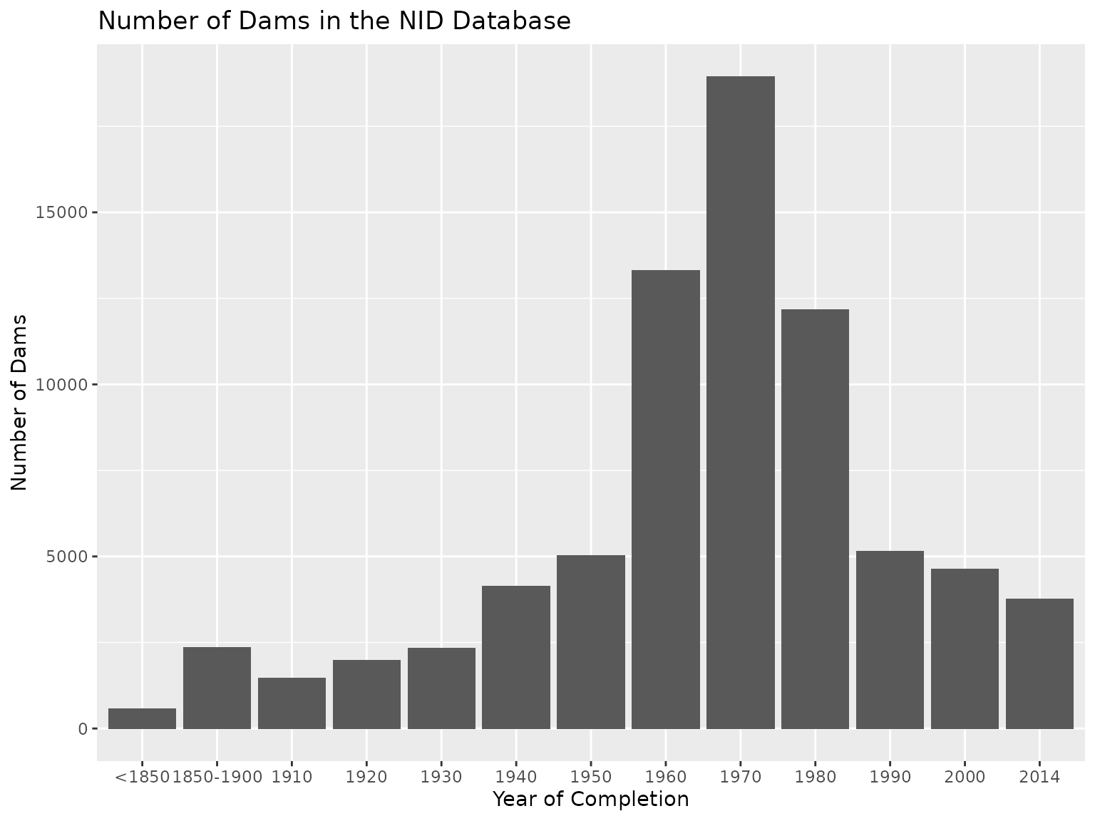
table(gfx_data$year)
##
## <1850 1850-1900 1910 1920 1930 1940 1950 1960
## 569 2351 1460 1992 2329 4144 5028 13318
## 1970 1980 1990 2000 2014
## 18935 12167 5148 4629 3770
year_counts <- as.data.frame(table(gfx_data$year), stringsAsFactors = FALSE)
colnames(year_counts) <- c("Year", "Count")
Histogram of number of dams by time period
gfx_bar <- ggplot(year_counts, aes(x = Year, y = Count))
gfx_bar <- gfx_bar + geom_bar(position = "dodge", stat = "identity")
gfx_bar <- gfx_bar + ylab("Number of Dams") + xlab("Year of Completion")
gfx_bar <- gfx_bar + ggtitle("Number of Dams in the NID Database")
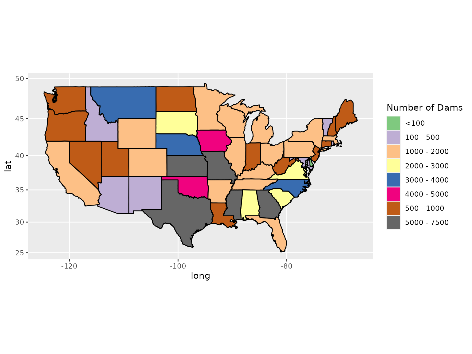
Counts of dams per state in the US mainland
##
##   DE   RI   VT   AZ   MD   NM   ID   NV   ME   WV   LA   NH   WA   NJ   CT   UT
##   83  234  368  376  400  407  472  525  581  586  609  652  802  834  845  860
##   OR   IN   ND   MI   WI   KY   FL   MN   TN   AR   MA   OH   PA   CA   WY   IL
##  882  912  933 1059 1065 1090 1109 1187 1241 1263 1327 1407 1514 1576 1613 1662
##   CO   NY   AL   SC   SD   VA   NE   NC   MT   IA   OK   GA   MO   MS   KS   TX
## 1803 1934 2273 2343 2562 2790 3007 3191 3306 4018 4986 5306 5379 6081 6403 7324
Map of dams per state in the US mainland
state_counts <- as.data.frame(table(gfx_data$state), stringsAsFactors = FALSE)
colnames(state_counts) <- c("state", "Count")

# add long names of states
state_names <- data.frame(state = state.abb,
                          name = state.name,
                          stringsAsFactors = FALSE)
gfx_data <- merge(state_counts, state_names, by = "state")
# change state name to lower case to be consistent with ggplot
gfx_data$name <- tolower(gfx_data$name)

# geo reference data on states from ggplot
geo_state <- map_data("state")

# merge data with above for graphics
gfx_data <- merge(geo_state, gfx_data, by.x = "region", by.y = "name")
gfx_data <- gfx_data[order(gfx_data$order), ]

# discretize state counts
color_breaks <- c(0, 100, 500, 1000, 2000, 3000, 4000, 5000, 7500)
color_labels <- c("<100", "100 - 500", "500 - 1000", "1000 - 2000",
                  "2000 - 3000", "3000 - 4000", "4000 - 5000", "5000 - 7500")
gfx_data$dams <- cut(gfx_data$Count,
                     breaks = color_breaks,
                     labels = color_labels)

gfx_map <- ggplot(data = gfx_data)
gfx_map <- gfx_map + geom_polygon(aes(x = long, y = lat, group = group,
            fill = dams))
gfx_map <- gfx_map + geom_path(data = geo_state, aes(x = long, y = lat,
            group = group, fill = NA))
## Warning: Ignoring unknown aesthetics: fill
gfx_map <- gfx_map + labs(list(title = "Number of Dams in the NID Database",
            x = NULL, y = NULL))
gfx_map <- gfx_map + guides(fill = guide_legend(title = "Number of Dams"))
gfx_map <- gfx_map + scale_fill_brewer(palette = "Accent")
gfx_map <- gfx_map + coord_map()
Other Analyses: Flood Control Dams
A number of interesting analyses could be performed with the dataset. Of interest to water resources managers and hydrologists is the location of flood control dams. It is interesting to see a few states like Texas have a large number of flood control dams.
##
##   AK   AL   AR   AZ   CA   CO   CT   DE   FL   GA   GU   HI   IA   ID   IL   IN
##  107 2273 1263  376 1576 1803  845   83 1109 5306    1  133 4018  472 1662  912
##   KS   KY   LA   MA   MD   ME   MI   MN   MO   MS   MT   NC   ND   NE   NH   NJ
## 6403 1090  609 1327  400  581 1059 1187 5379 6081 3306 3191  933 3007  652  834
##   NM   NV   NY   OH   OK   OR   PA   PR   RI   SC   SD   TN   TX   UT   VA   VT
##  407  525 1934 1407 4986  882 1514   36  234 2343 2562 1241 7324  860 2790  368
##   WA   WI   WV   WY
##  802 1065  586 1613